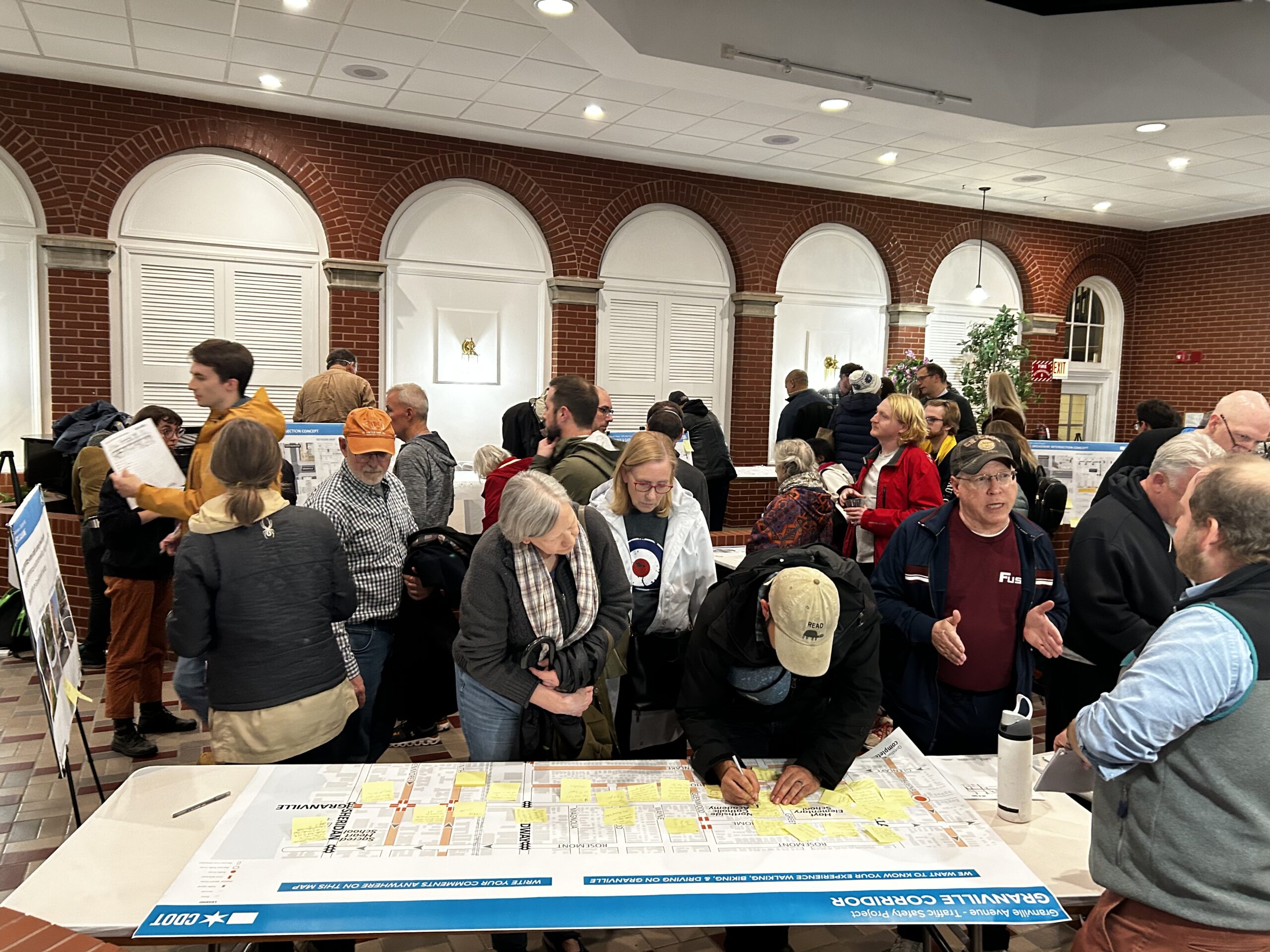
Thank you to all of the neighbors who attended last night’s Granville Traffic Safety Meeting! For years now we have been hearing from 40th Ward neighbors with concerns about the dangerous traffic conditions on Granville Avenue, and we’re thrilled to be partnering with the Department of Transportation (CDOT) and the 48th and 50th Ward offices to address these issues.
At Tuesday’s meeting, representatives from CDOT’s Complete Streets Team presented data on how Granville is currently being used, and a plan to calm traffic and improve safety throughout the corridor. For those who weren’t able to attend, you can view a recording of the video below and/or visit CDOT’s Complete Streets to view maps and exhibits from the meeting.
Read on for a summary of what we learned from the meeting!
Granville is a traffic safety hot spot.
High Traffic Volumes
CDOT reports that there is three times the traffic volume on Granville than that of a typical residential street. Granville has an average daily traffic volume of 7,000 cars, which is about exponentially higher than other neighborhood streets.
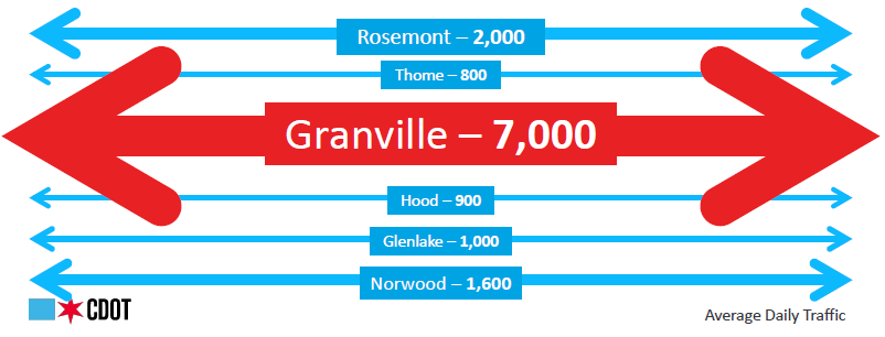
For comparison, average daily traffic volumes on neighboring streets are 2,000 on Rosemont, 1,600 on Norwood, 1,000 on Glenlake, 900 on Hood, and 800 on Thome.
The majority of this traffic is likely due to the fact that Granville is used as a cut-through street for drivers looking to avoid busier streets like Devon and Peterson. Granville is one of the only residential streets that is two-way for an entire 16-mile stretch.
The amount of drivers using Granville as a cut-through has a significant impact on the health of the neighborhood—88% of drivers who have caused a serious injury live outside of the neighborhood.
Dangerously High Speeds
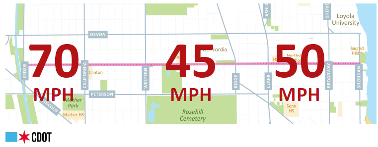
People are driving at deadly speeds along Granville Avenue every day, with speeds up to 70MPH being recorded on this street.
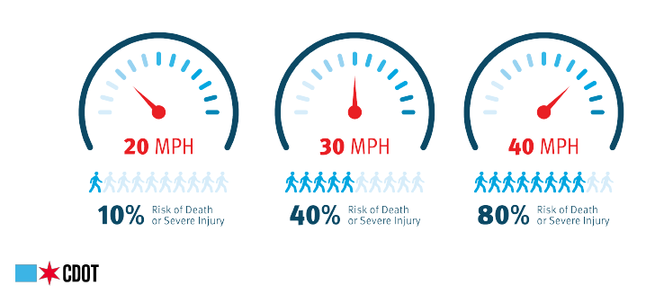
The speed at which a vehicle is driving massively increases the risk of death or serious injury:
- If a person is hit by a car traveling at 20MPH, they have a 10% risk of death or severe injury
- If a person is hit by a car traveling at 30MPH, they have a 40% risk of death or severe injury
- If a person is hit by a car traveling at 40MPH, they have a 80% risk of death or severe injury—that means they only have a 20% chance of surviving being hit unscathed or with only minor injuries.
Traffic Crashes and Injuries
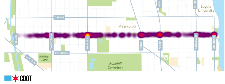
Crashes occur at 10x the rate of all other local neighborhood streets, with over half of all pedestrian and bike crashes in the neighborhood happening on Granville. Over the past five years, there have been 664 total crashes on Granville Avenue, and 182 people have been injured.
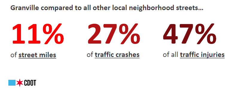
While Granville only makes up 11% of the local neighborhood street network, compared to other neighborhood streets, Granville accounts for 27% of traffic crashes, and 47% of traffic injuries.
- 27% if those injuries were suffered by children and teenagers under the age of 18, and as low as 10 years old;
- 10% were suffered by seniors over the age of 20.
In talking to schools located along the corridor, every single school identified the safety of students during pick-up and drop-off as a major concern. The data bears out those concerns: 20% of crashes on Granville occurred during school pick-up and drop-off times.
While crashes happen all along Granville, they are especially prevalent at major intersections including Western, Ridge, Clark, Broadway, and Sheridan.
Turning Granville from a cut-through street to a community street
To improve the safety for everyone who lives or relies on Granville, CDOT proposed a traffic calming plan with the following goals:
- Fewer Trips: Reconfigure the street network to discourage non-local traffic
- Safer Speeds: Provide traffic calming infrastructure like curb extensions or traffic circles at targeted locations based on neighborhood experiences
- Better Organization: Improve school pick-up/drop-off operations, provide better circulation within the neighborhood, and preserve emergency services access
- Enhance Access: make walking safer and more comfortable for pedestrians, improve access to transit, and establish a formal neighborhood bike route on Granville
Since the majority of crashes are happening near major intersections, CDOT has identified several major intersections where they propose shifting the adjacent 1-2 blocks from a two-way street to a one-way street.
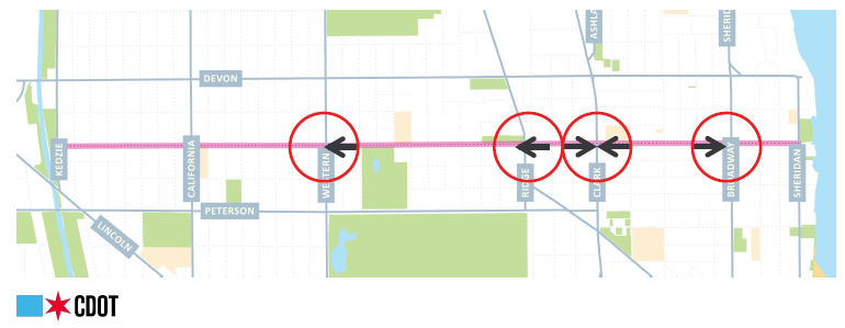
- Granville and Western: Granville between Western and Oakley would be converted to a one-way west-bound.
- Granville and Ridge: Granville between Ravenswood and Hermitage would be converted to a one-way westbound
- Granville and Clark: Granville between Paulina and Clark would be converted to a one-way eastbound; Granville between Greenview and Clark would be converted to a one-way westbound.
- Granville and Broadway: Granville between Broadway and Lakewood would be converted to a one-way westbound.
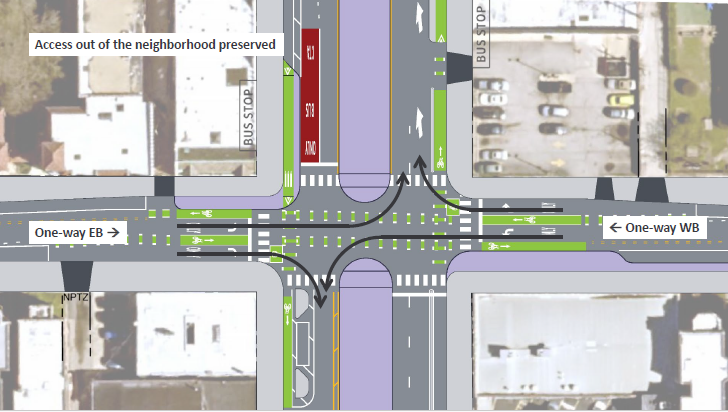
These changes will preserve neighborhood access, which discouraging cut-through traffic. It will also allow for the creation of an established neighborhood bike route; many neighbors already use Granville for this purpose, as there are no other east-west bike routes within a two mile stretch of the northside, so this project would formalize that by installing a greenway that allows two-way bike traffic.
Community Engagement + Next Steps
At our community meeting on October 15th, representatives from CDOT presented the proposal and neighbors had the opportunity to ask questions and give feedback. You can view the proposal in full on CDOT’s Complete Streets website.
In addition to the public meeting, CDOT and Ward offices have also met with local block clubs, the Chicago Fire Department, and all of the schools along Granville to get their feedback. All of the schools have been in support of the plan, and the CFD has confirmed that the proposed plan would not impact emergency vehicle access. We are also continuing to work with local block clubs to identify their concerns, so that they can be addressed as CDOT finalizes the project design.
Now we want to hear from you! Please email your questions and feedback to completestreets@cityofchicago.org.
Over the next few weeks, CDOT will compile and review the feedback, and report back to Ward offices to determine next steps. The goal is to have the project design completed by early 2025, for eventual construction in Summer 2025.