40th Ward Western Avenue Proactive Rezone
On Wednesday, July 17th, the 40th Ward portion of the Western Avenue Rezone was introduced in City Council!
This proactive rezoning is the first of its kind in the city of Chicago, and we’re enormously proud to be a part of this effort, which has been years in the making. We are grateful for the leadership of the Department of Planning and Development (DPD), the partnership of Alderman Matt Martin and Alderwoman Maria Hadden, who are joining us in rezoning the 47th and 49th Ward stretches of Western Avenue, and to Alderwoman Deborah Silverstein, for her initial vision for the Western Avenue Corridor Study. Most of all, we are grateful to all of the community members who took part in reimagining Western Avenue.
Western Corridor Study
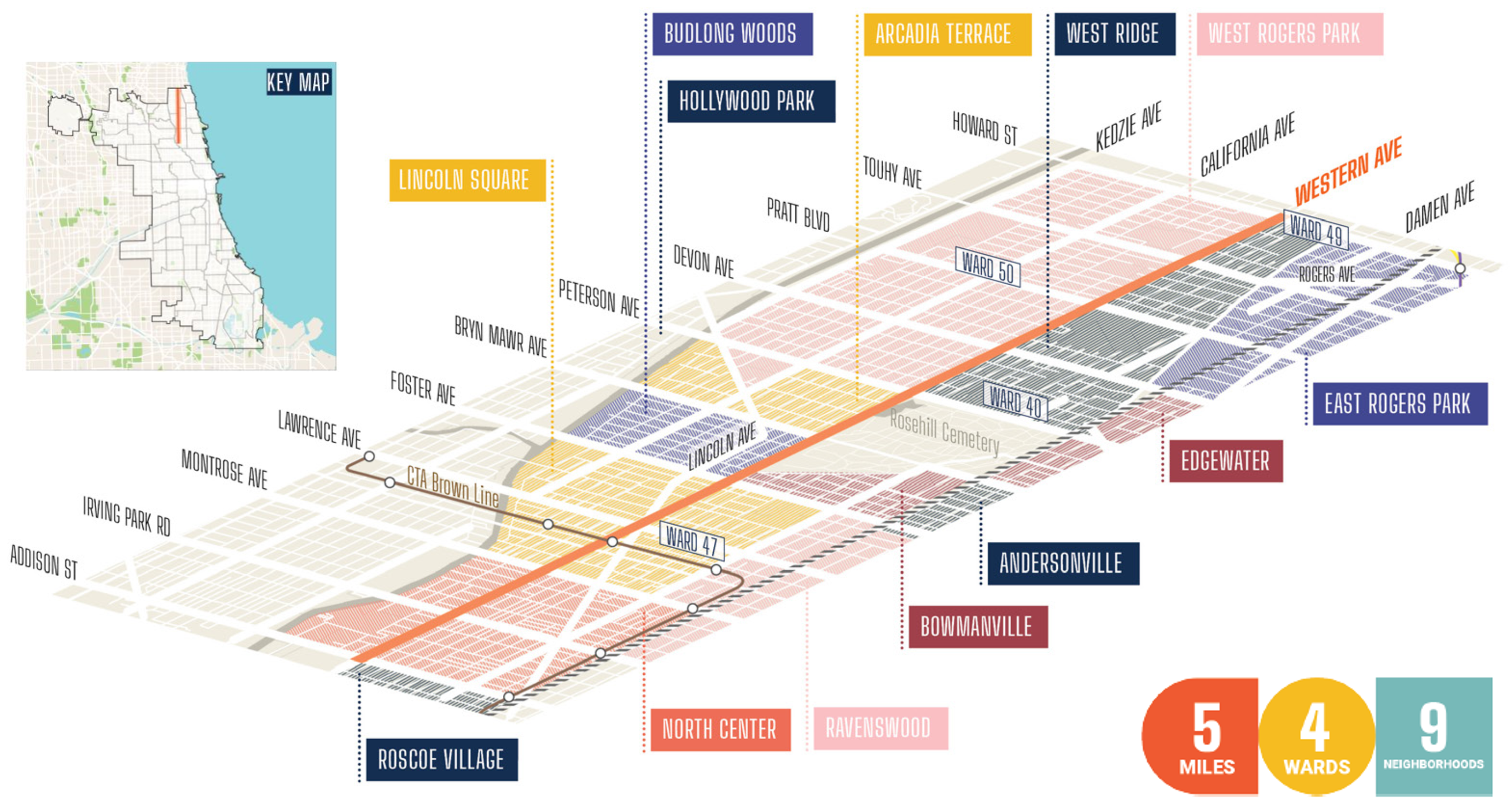
The Western Avenue Corridor Study was an 18-month community planning initiative to reimagine a 5-mile section of Western Avenue, so that it could better serve the community. The plan was adopted by the Chicago Plan Commission in November 2022 and is now used as the guiding document for planning decisions along the corridor.
The initiative was led by the Chicago Department of Planning & Development (DPD) and the Department of Transportation (CDOT), along with the 40th Ward, 47th Ward, 49th Ward, and 50th Ward Offices. Other neighborhood organizations that were involved include the Heart of Lincoln Square Neighbors Association, the West Ridge Community Organization, the North Center Neighborhood Association, the Lincoln Square Ravenswood Chamber of Commerce, the Rogers Park Business Alliance, the West Ridge Chamber of Commerce, and the North Center Chamber of Commerce.
Together, these groups, along with other City Departments and advocacy groups, conducted focus groups and public feedback sessions to get a sense of our neighbors concerns about Western Avenue, and their vision for how it could better serve the community. Through this process, the study identified 3 strategic goals: 1) developing thriving neighborhood centers, 2) creating safe and attractive streets through better pedestrian infrastructure and access to transit, and 3) improving environmental, sociocultural, and economic resilience, by introducing new public spaces, more landscaping and sustainable design, and mixed-use development opportunities.
The Western Avenue Rezoning addresses the first of these goals––creating thriving, mixed-use neighborhood centers that celebrate and enhance the corridor’s identity and experience, support a diverse local economy, and encourage new housing opportunities for a range of affordability levels while also protecting existing housing stock that is affordable to lower income residents.
Approach to Zoning and Land Use Framework
In considering how to implement the community’s priorities as identified through the Western Avenue Corridor Study, the DPD identified the following land uses:
- Neighborhood Centers: hubs of concentrated mixed-use activity that meet a variety of daily needs. These would include buildings with an active ground floor, and housing and/or office space above the ground floor.
- Housing infill: prioritized areas for increasing housing. This would include both residential buildings and small-scale neighborhood-serving commercial businesses (e.g. coffee shops, salons, laundromat, etc.) on the the ground floor.
- Dominant commercial area: commercial uses at the ground floor with potential office and/or residential above.
The primary zoning district recommended for Western Avenue was B3-3, as it serves most of the uses listed above.
The Impact of the Western Avenue Rezoning
The 40th Ward stretch of Western Avenue is now majority B3-3. This will impact the development potential of these properties by changing future allowed uses and basic development regulations (e.g. height or setbacks) to align with the recommendations of the study and the priorities of the community. View the updated zoning maps to see what those changes look like in detail.
Current Properties
For the most part, there are no immediate impacts to existing properties. There were eleven properties in the 40th Ward stretch of Western Avenue that were identified as non-conforming or requiring special use; however, this would generally only be an issue if a business wanted to change the exterior of the building, or if the business was closed for more than 18 months.
The 40th Ward reached out to each of these businesses individually to explain the change, and make sure that they had no upcoming plans that would be impacted by the rezoning. If you have any questions about the impacts to a specific property, contact our office at 40thward.org/contact.
New Development
This zoning change is proactive, so it’s important to note that there are no proposed development projects on these properties at this time. The change in zoning is meant to encourage development by changing the allowed uses to those that support the community’s priorities for development. You can learn more about these allowed uses starting on page 19 of the presentation below.
If you’d like to learn more about the land use framework, allowed uses, and property impacts, take a look at the presentation below!