Project Summary
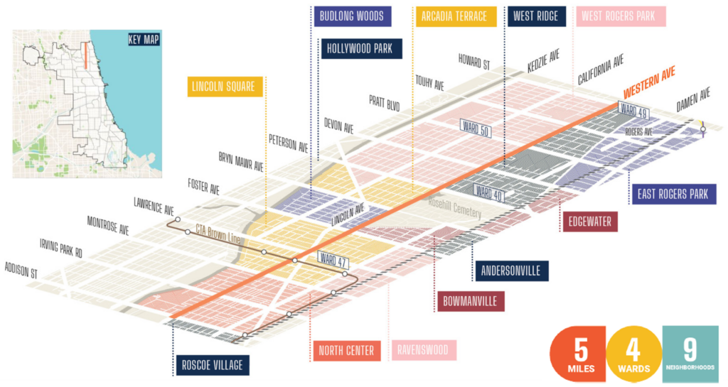
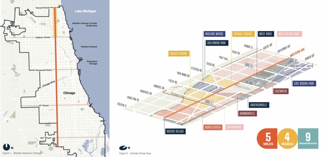
The Western Avenue Corridor study examines the land uses, development patterns, and circulation along this heavily traveled and diverse corridor. A community-based planning initiative led by the Department of Planning and Development (DPD) and the Chicago Department of Transportation (CDOT), this process will envision an equitable, long-term future for a five-mile section of North Western Avenue, from Addison Street to Howard Street.
The final Western Avenue Corridor Study is the outcome of an 18-month community-driven planning initiative to envision an equitable, long-term future for a five-mile section of North Western Avenue, including all of Western Avenue in the 40th Ward.
In 2024, the 40th Ward initiated a proactive rezone of the entire stretch of Western Avenue located within the 40th Ward, as part of the implementation of the Western Ave Corridor Study vision. See details in the construction updates section below or at 40thward.org/WesternRezone.
Project Overview
- Neighborhood: West Rogers Park, West Ridge, Arcadia Terrace, Budlong Woods, Lincoln Square
- Zip Code: 60645, 60659, 60625
- Scope and boundaries: Western Avenue from Howard Street to Addison Street
- Timeline: Spring 2021-Summer 2024
- Project Website
Status: Completed
Quick Links
Scope & Design
Western Avenue Corridor Study
Western Avenue is a major regional arterial corridor in Chicago. Running uninterrupted, from the northern to southern city limits, it connects 16 of the City’s 77 community areas. The northernmost five miles of the Western Avenue corridor, which is the focus of this study, links northside communities while playing a vital role in the regional transportation system to move people and goods. Western Avenue, as a place, is a daily fixture and background for many Chicagoans’ lives. Over 100,000 residents live within a half mile of this study area, according to the 2020 Census.
Project Goals
- Increase density
- Promote a greater mix of land uses
- Improve how development relates to the
surrounding, lower-scaled residential areas - Enhance pedestrian safety and experience
Press & Media
Design Exhibits
- Implementation Update: Western Ave Corridor Study – Adopted Nov 2022, (PDF, 86.6MB)
- Existing and Proposed Zoning Maps — 40th Ward (PDF)
- Existing and Proposed Zoning Maps — 47th Ward (PDF)
- Project Background and Zoning Overview Slideshow (PDF)
Project Features
The community-led planning process launched in early 2021. Results were published in November 2022. Key components:
- Building consensus with the Western Avenue communities through a public planning process to establish a shared vision for the future
- Reviewing and analyzing corridor attributes and conditions, such as land use, zoning, parking and bike facilities, pedestrian safety, public amenities, and more
- Establishing a long-term vision for the corridor that includes future land use and zoning recommendations, design guidelines, potential public right-of-way improvements, and implementation objectives
- Developing a “Resource Reference Guide” for corridor stakeholders that identifies available tools and City resources to promote growth and improvement of the corridor
Timeline & Construction Updates
Project Timeline
- Public Engagement: Winter 2021-Summer 2022
- Study Completion: Fall 2022
- Study Implementation: Summer 2024
Construction Updates
As part of the implementation of the Western Avenue Corridor vision outlined in the study, our office is initiating a proactive rezone of the entire stretch of Western Avenue located within the 40th Ward.
Many of the current zoning districts along this stretch of Western Avenue will be changed to zoning districts that better align with the recommendations described in the Western Avenue Corridor Study.
This zoning change is proactive, so while there are no proposed development projects on these properties at this time, we are hopeful that this rezoning will impact the development potential of these properties by changing future allowed uses and basic development regulations (e.g. height or setbacks) to support the community’s priorities for land use and development in this area. Learn more about the approach to zoning and impacts to properties at 40thward.org/WesternRezone.
Engagement
Community Meetings
The plan was adopted by the Chicago Plan Commission in November 2022 and is now used as the guiding document for planning decisions along the corridor.
Archived Public Meetings
- Final presentation, video recording, October 6th, 2022
Subscribe to Updates
From the blog